
Caserta topographic map
Interactive map
Click on the map to display elevation.
About this map
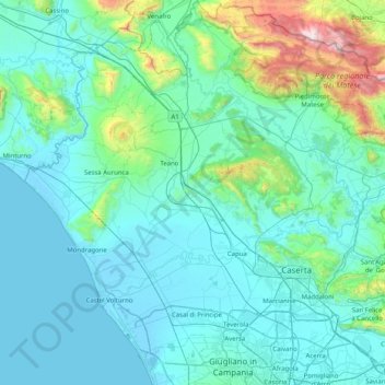
Name: Caserta topographic map, elevation, terrain.
Location: Caserta, Campania, Italy (40.89878 13.76238 41.50808 14.53531)
Average elevation: 228 m
Minimum elevation: -3 m
Maximum elevation: 2,014 m
Other topographic maps
Click on a map to view its topography, its elevation and its terrain.
Naples
Italy > Campania > Napoli > Naples
The city is situated on the Gulf of Naples, on the western coast of southern Italy; it rises from sea level to an elevation of 450 metres (1,480 ft). The small rivers which formerly crossed the centre of the city have since been covered over by construction. It lies between two notable volcanic regions, Mount…
Average elevation: 58 m