
Barrington topographic map
Interactive map
Click on the map to display elevation.
Barrington
Barrington lies on a low, mostly flat plain bordering the sea. This plain, composed mostly of layers of clay, gravel, sand, and silt soils, was formed by a melting glacier towards the end of the last ice age.:2–5:1 Bedrock underlying the soil is largely composed of shales, sandstone, and conglomerate rock, with some outcrops of quartz. A few extremes in elevation, such as Nayatt Point, Primrose and Prince's Hill, rise to heights of fifty feet.:1
About this map
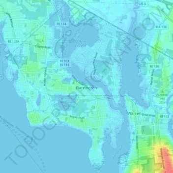
Name: Barrington topographic map, elevation, terrain.
Location: Barrington, Rhode Island, 02806, United States of America (41.70606 -71.35317 41.77614 -71.28534)
Average elevation: 4 m
Minimum elevation: -7 m
Maximum elevation: 47 m