
Make a donation
Gear up for your next adventure:
As an Amazon Associate, this site earns from qualifying purchases at no extra cost to you.
Coniston Water topographic map
Click on the map to display elevation.
Make a donation
Gear up for your next adventure:
As an Amazon Associate, this site earns from qualifying purchases at no extra cost to you.
Coniston Water
Coniston Water in the English county of Cumbria is the third-largest lake in the Lake District by volume (after Windermere and Ullswater), and the fifth-largest by area. It is five miles long by half a mile wide (8 km by 800 m), has a maximum depth of 184 feet (56 m), and covers an area of 1.89 square miles (4.9 km2). The lake has an elevation of 143 feet (44 m) above sea level. It drains to the sea via the River Crake.
Make a donation
Gear up for your next adventure:
As an Amazon Associate, this site earns from qualifying purchases at no extra cost to you.
About this map
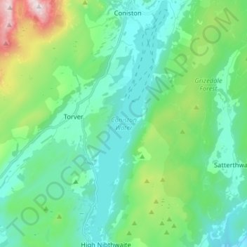
Name: Coniston Water topographic map, elevation, terrain.
Average elevation: 186 m
Minimum elevation: 17 m
Maximum elevation: 791 m
Make a donation
Gear up for your next adventure:
As an Amazon Associate, this site earns from qualifying purchases at no extra cost to you.