
Saint-Malo topographic map
Interactive map
Click on the map to display elevation.
About this map
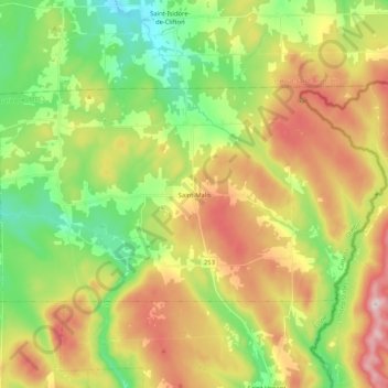
Name: Saint-Malo topographic map, elevation, terrain.
Location: Saint-Malo, Coaticook (MRC), Estrie, Quebec, Canada (45.15942 -71.60477 45.24086 -71.39735)
Average elevation: 484 m
Minimum elevation: 323 m
Maximum elevation: 707 m
Saint-Malo (local pronunciation) is a municipality in Quebec, Canada, on the Canada–United States border. Saint-Malo has the highest elevation of any municipality in Quebec. At 640 metres (2,100 ft), local residents live in an environment of forests, farms, and waterways that supply their livelihood.
Other topographic maps
Click on a map to view its topography, its elevation and its terrain.
Dufferin Heights
Canada > Quebec > Coaticook (MRC)
Dufferin Heights, Stanstead-Est, Coaticook (MRC), Estrie, Quebec, Canada
Average elevation: 380 m
Martinville
Canada > Quebec > Coaticook (MRC)
Martinville, Coaticook (MRC), Estrie, Quebec, Canada
Average elevation: 307 m
Sainte-Edwidge-de-Clifton
Canada > Quebec > Coaticook (MRC)
Sainte-Edwidge-de-Clifton, Coaticook (MRC), Estrie, Quebec, Canada
Average elevation: 387 m
Coaticook
Canada > Quebec > Coaticook (MRC)
Coaticook, Coaticook (MRC), Estrie, Quebec, Canada
Average elevation: 439 m
Moe's River
Canada > Quebec > Coaticook (MRC) > Compton
Moe's River, Compton, Coaticook (MRC), Estrie, Quebec, J1M 2A2, Canada
Average elevation: 282 m