
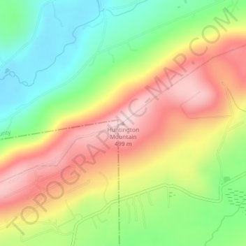
Huntington Mountain topographic map
Interactive map
Click on the map to display elevation.
About this map
Name: Huntington Mountain topographic map, elevation, terrain.
Average elevation: 349 m
Minimum elevation: 211 m
Maximum elevation: 500 m
Other topographic maps
Click on a map to view its topography, its elevation and its terrain.
Bridgeville
United States of America > Pennsylvania > Bridgeville
According to the United States Census Bureau, the borough has a total area of 1.1 square miles (2.8 km2), all of it land. Its average elevation is 1,250 ft (381 m) above sea level.
Average elevation: 275 m
Buckingham Township
United States of America > Pennsylvania > Buckingham Township
Average elevation: 90 m
Bell Acres
United States of America > Pennsylvania > Bell Acres
According to the United States Census Bureau, the borough has a total area of 5.2 square miles (13 km2), all of it land. Its average elevation is 965 feet (294 m) above sea level.
Average elevation: 316 m