Geolocate

Brushy Creek topographic map

Interactive map

Click on the map to display elevation.

About this map

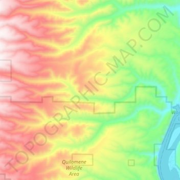
Name: Brushy Creek topographic map, elevation, terrain.

Location: Brushy Creek, Kittitas County, Washington, United States of America (47.11266 -120.21032 47.13716 -120.02567)

Average elevation: 653 m

Minimum elevation: 160 m

Maximum elevation: 1,222 m

Other topographic maps

Click on a map to view its topography, its elevation and its terrain.

Orcas

United States of America > Washington > Orcas

Average elevation: 39 m

Oxley

United States of America > Washington > Oxley

Average elevation: 85 m

Harbert

United States of America > Washington > Harbert

Average elevation: 411 m

Manitou

United States of America > Washington > Tacoma > Manitou

Average elevation: 82 m

Cowlitz

United States of America > Washington > Cowlitz

Average elevation: 79 m

Mission Peak

United States of America > Washington

Average elevation: 1,829 m

Grouse

United States of America > Washington > Grouse

Average elevation: 963 m

Diamond Head

United States of America > Washington

Average elevation: 1,571 m