
Shkodër County topographic map
Interactive map
Click on the map to display elevation.
About this map
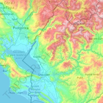
Name: Shkodër County topographic map, elevation, terrain.
Location: Shkodër County, Northern Albania, Albania (41.84032 19.28085 42.66108 20.24827)
Average elevation: 685 m
Minimum elevation: -5 m
Maximum elevation: 2,665 m
The county has a wide variety of topographical sets and natural landscapes. The Albanian Alps, which extends in the north of the county toward Montenegro, is a primarily mountainous region with a high terrain. The alps delineated several sedimentary basins such as the Mbishkodra basin in the center. The highest point in the county is Maja Jezercë at 2,694 m (8,839 ft) above the Adriatic in the northeast shared with Kukës County. The lowest spot is 0 m (0 ft) above the Adriatic, located in the southwest of the county.
Other topographic maps
Click on a map to view its topography, its elevation and its terrain.
Dibër County
Dibër County, Northern Albania, Albania
Average elevation: 914 m
Shkoder
Albania > Northern Albania > Shkoder
Shkoder, Shkodër Municipality, Shkodër County, Northern Albania, 4001-4007, Albania
Average elevation: 47 m