
Western Development Region topographic map
Interactive map
Click on the map to display elevation.
About this map
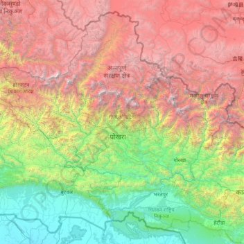
Name: Western Development Region topographic map, elevation, terrain.
Location: Western Development Region, Nepal (27.33016 82.69618 29.33061 85.19783)
Average elevation: 2,421 m
Minimum elevation: 81 m
Maximum elevation: 7,949 m
Other topographic maps
Click on a map to view its topography, its elevation and its terrain.
Ghandruk
Nepal > Western Development Region > Ghandruk
Ghandruk, Kaski, Gandaki, Western Development Region, Nepal
Average elevation: 3,527 m
Dhaulagiri
Nepal > Western Development Region > Mudi
Dhaulagiri, Mudi, Myagdi, Dhaulagiri, Western Development Region, Nepal
Average elevation: 7,321 m
Annapurna II
Nepal > Western Development Region > Parche
Annapurna II, Parche, Kaski, Gandaki, Western Development Region, Nepal
Average elevation: 7,052 m
Darling
Nepal > Western Development Region > Darling
Darling, Malika, Gulmi, Western Development Region, Province #5, Nepal
Average elevation: 1,681 m
Bhonje
Nepal > Western Development Region > Bhonje
Bhonje, Lamjung, Gandaki, Western Development Region, Nepal
Average elevation: 1,265 m
Muna
Nepal > Western Development Region > Muna
Muna, Myagdi, Dhaulagiri, Western Development Region, Nepal
Average elevation: 2,230 m
Annapurna I
Nepal > Western Development Region > Ghandruk
Annapurna I, Ghandruk, Kaski, Gandaki, Western Development Region, Nepal
Average elevation: 7,127 m