
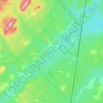
Saint-Just-de-Bretenières topographic map
Interactive map
Click on the map to display elevation.
About this map
Name: Saint-Just-de-Bretenières topographic map, elevation, terrain.
Average elevation: 382 m
Minimum elevation: 331 m
Maximum elevation: 575 m
Other topographic maps
Click on a map to view its topography, its elevation and its terrain.
Sainte-Apolline-de-Patton
Canada > Quebec > Montmagny (MRC)
Sainte-Apolline-de-Patton, Montmagny (MRC), Chaudière-Appalaches, Quebec, Canada
Average elevation: 434 m
Montmagny
Canada > Quebec > Montmagny (MRC) > Montmagny
Montmagny, Montmagny (MRC), Chaudiere-Appalaches, Quebec, Canada
Average elevation: 169 m