
Lions Head topographic map
Interactive map
Click on the map to display elevation.
About this map
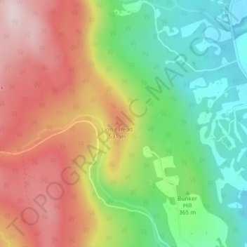
Name: Lions Head topographic map, elevation, terrain.
Location: Lions Head, Litchfield County, Connecticut, 06968, USA (42.00726 -73.44600 42.00736 -73.44590)
Average elevation: 403 m
Minimum elevation: 226 m
Maximum elevation: 603 m
Other topographic maps
Click on a map to view its topography, its elevation and its terrain.
South Windsor
USA > Connecticut > South Windsor
South Windsor, Hartford County, Connecticut, 06074, USA
Average elevation: 40 m
Wallingford
USA > Connecticut > Wallingford
Wallingford, New Haven County, Connecticut, 06492, USA
Average elevation: 61 m
Poquonock
USA > Connecticut > Windsor > Poquonock
Poquonock, Windsor, Hartford County, Connecticut, 06095, USA
Average elevation: 36 m
Stonington
USA > Connecticut > Stonington
Stonington, New London County, Connecticut, USA
Average elevation: 3 m
Cos Cob
USA > Connecticut > Cos Cob
Cos Cob, Fairfield, Connecticut, 06807, USA
Average elevation: 17 m
Major Island
Major Island, New London County, Connecticut, USA
Average elevation: 16 m