
Altenburg topographic map
Interactive map
Click on the map to display elevation.
About this map
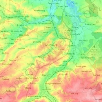
Name: Altenburg topographic map, elevation, terrain.
Location: Altenburg, Altenburger Land, Thuringia, 04600, Germany (50.92220 12.37216 51.03470 12.49569)
Average elevation: 207 m
Minimum elevation: 153 m
Maximum elevation: 269 m
Altenburg is located on the southern edge of the Leipzig Bay, a flat and fertile area, with intensive agricultural use and lignite surface mining 10 km (6 mi) north of the town. The nearest mountains are the Ore Mountains approximately 50 km (31 mi) to the south-east. The Pleiße valley runs east of the city, whereas the center itself is located at Blaue Flut (blue flood) river, a small tributary of Pleiße river. The Blaue Flut feeds the Großer Teich (big pond), an inner-city pond with an island in the middle, on which the Altenburg zoo is located. There is relatively little forest within the town's municipal territory: the small Stadtwald (town wood) and Herzog-Ernst-Wald (Duke Ernest wood) south of the center and the Fasanerieholz (Pheasantry wood) at Ehrenberg district. The elevation of the city center is 200 m, to the north it declines down to 162 m and in the south next to Mockzig district it rises up to 261 m.