
Fernie topographic map
Interactive map
Click on the map to display elevation.
About this map
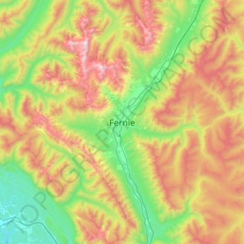
Name: Fernie topographic map, elevation, terrain.
Average elevation: 1,551 m
Minimum elevation: 794 m
Maximum elevation: 2,835 m
Other topographic maps
Click on a map to view its topography, its elevation and its terrain.
Maiden Lake
Canada > British Columbia > Regional District of East Kootenay > Fernie
Maiden Lake, Fernie, Regional District of East Kootenay, British Columbia, Canada
Average elevation: 1,045 m