
Cublac topographic map
Interactive map
Click on the map to display elevation.
About this map
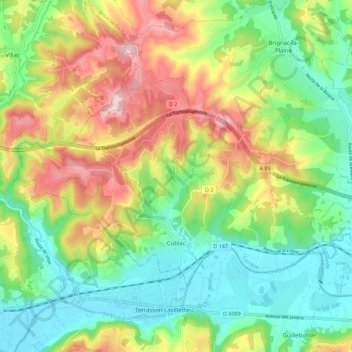
Name: Cublac topographic map, elevation, terrain.
Average elevation: 178 m
Minimum elevation: 79 m
Maximum elevation: 333 m
Other topographic maps
Click on a map to view its topography, its elevation and its terrain.
Saint-Bazile-de-la-Roche
France > Nouvelle-Aquitaine > Corrèze > Argentat-sur-Dordogne
Saint-Bazile-de-la-Roche, Argentat-sur-Dordogne, Tulle, Corrèze, Nouvelle-Aquitaine, Metropolitan France, France
Average elevation: 397 m
Brive-la-Gaillarde
France > Nouvelle-Aquitaine > Corrèze
Brive-la-Gaillarde, Corrèze, Nouvelle-Aquitaine, Metropolitan France, 19100, France
Average elevation: 178 m