
Brigus Junction topographic map
Interactive map
Click on the map to display elevation.
About this map
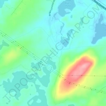
Name: Brigus Junction topographic map, elevation, terrain.
Average elevation: 140 m
Minimum elevation: 109 m
Maximum elevation: 228 m
Newfoundland and Labrador trails, hiking, mountain biking, running and outdoor activities
Other topographic maps
Click on a map to view its topography, its elevation and its terrain.
Outer Cove
Canada > Newfoundland and Labrador > Logy Bay-Middle Cove-Outer Cove
Average elevation: 47 m
Memorial University of Newfoundland main campus
Canada > Newfoundland and Labrador > St. John's
Average elevation: 78 m
Pistolet Bay Provincial Park
Canada > Newfoundland and Labrador > unincorporated Newfoundland
Average elevation: 21 m
Pistolet Bay Provincial Park
Canada > Newfoundland and Labrador > unincorporated Newfoundland
Average elevation: 21 m
Portugal Cove
Canada > Newfoundland and Labrador > Portugal Cove - St. Philips
Average elevation: 61 m