
Leawood topographic map
Interactive map
Click on the map to display elevation.
About this map
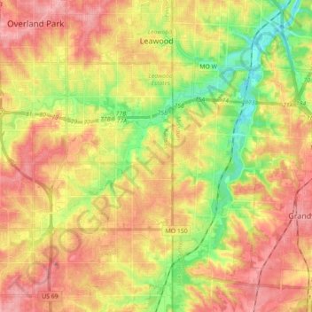
Name: Leawood topographic map, elevation, terrain.
Location: Leawood, Johnson County, Kansas, United States (38.84734 -94.64922 38.98436 -94.60781)
Average elevation: 289 m
Minimum elevation: 235 m
Maximum elevation: 333 m
Other topographic maps
Click on a map to view its topography, its elevation and its terrain.
Overland Park
United States > Kansas > Johnson County
Overland Park, Johnson County, Kansas, United States
Average elevation: 300 m
Olathe
United States > Kansas > Johnson County
Olathe, Johnson County, Kansas, United States
Average elevation: 309 m
Zarah
United States > Kansas > Johnson County > Shawnee
Zarah, Shawnee, Johnson County, Kansas, 66218, United States
Average elevation: 268 m