
Ridgeway topographic map
Interactive map
Click on the map to display elevation.
About this map
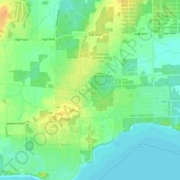
Name: Ridgeway topographic map, elevation, terrain.
Average elevation: 184 m
Minimum elevation: 171 m
Maximum elevation: 202 m
Niagara Region trails, hiking, mountain biking, running and outdoor activities
Other topographic maps
Click on a map to view its topography, its elevation and its terrain.
Niagara River
Canada > Ontario > Niagara Region > Fort Erie
The river, which is occasionally described as a strait, is about 58 kilometres (36 mi) long and includes Niagara Falls in its course. The falls have moved approximately 11 kilometres (6.8 mi) upstream from the Niagara Escarpment in the last 12,000 years, resulting in a gorge below the falls. Today, the…
Average elevation: 177 m