
Kicking Horse topographic map
Interactive map
Click on the map to display elevation.
About this map
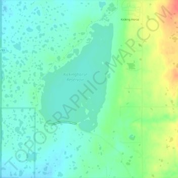
Name: Kicking Horse topographic map, elevation, terrain.
Location: Kicking Horse, Lake County, Montana, United States (47.44261 -114.09698 47.47892 -114.05407)
Average elevation: 938 m
Minimum elevation: 922 m
Maximum elevation: 973 m
Other topographic maps
Click on a map to view its topography, its elevation and its terrain.
Wild Horse Island
United States > Montana > Lake County
The island was formed by the Cordilleran Glacier, giving the island a varying topography. Its shores are 2,900 feet (880 m) above sea level. The glacier caused the six summits in the center of the island, ranging in heights between 3,277 and 3,745 feet (999 and 1,141 m), to be formed into rôche moutonnée,…
Average elevation: 916 m