
Freshwater topographic map
Interactive map
Click on the map to display elevation.
About this map
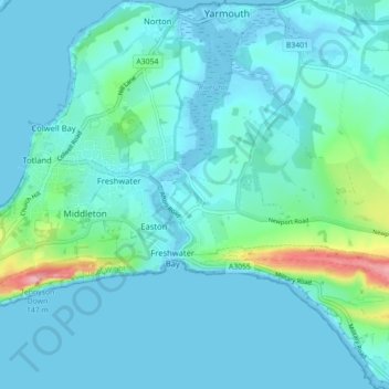
Name: Freshwater topographic map, elevation, terrain.
Location: Freshwater, Isle of Wight, England, United Kingdom (50.65151 -1.53881 50.70734 -1.46059)
Average elevation: 15 m
Minimum elevation: -4 m
Maximum elevation: 145 m
Other topographic maps
Click on a map to view its topography, its elevation and its terrain.
East Cowes
United Kingdom > England > Isle of Wight
East Cowes, Isle of Wight, England, United Kingdom
Average elevation: 27 m
Isle of Wight
United Kingdom > England > Isle of Wight
Isle of Wight, England, United Kingdom
Average elevation: 17 m
Colwell Bay
United Kingdom > England > Isle of Wight > Colwell Bay
Colwell Bay, Totland, Isle of Wight, South East England, England, PO40 9NP, United Kingdom
Average elevation: 16 m