
The Arboretum topographic map
Interactive map
Click on the map to display elevation.
The Arboretum
Victoria Woods is an old-growth hardwood forest made up of sugar maple, white ash, black cherry and beech. Varied topography in this area, which includes a pond, allows for a wide variety of woodland plants to grow here. Spring is an especially nice time to visit Victoria Woods to see many of these spring ephemeral plants blooming. High moisture content in this woodland's soils make it unsuitable for agriculture, which is a reason why its trees have never been cut.
About this map
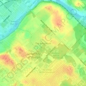
Name: The Arboretum topographic map, elevation, terrain.
Location: The Arboretum, Guelph, Ontario, Canada (43.53299 -80.22264 43.54518 -80.20741)
Average elevation: 332 m
Minimum elevation: 308 m
Maximum elevation: 352 m
Ontario trails, hiking, mountain biking, running and outdoor activities
Other topographic maps
Click on a map to view its topography, its elevation and its terrain.
Guelph
This region of Ontario has cold winters and warm, humid summers, falling into the Köppen climate classification Dfb zone, with moderately high rainfall and snowfall. It is generally a couple of degrees cooler than lower elevation regions on the Great Lakes shorelines, especially so in winter, the exception…
Average elevation: 344 m