
Levico Terme topographic map
Interactive map
Click on the map to display elevation.
Levico Terme
The town is dominated by the mountains of the Lagorai range on the north, with Monte Fronte, elevation 1,582 metres (5,190 ft), and Monte Panarotta (2,002 metres (6,568 ft)), and the zone of the Plateaus (Vezzena, Lavarone, Luserna, Folgaria) on the south, where Cima Vezzena, also locally called Pizzo di Levico 1,908 metres (6,260 ft), with its distinctive Austro-Hungarian fort on its top, and Cima Pegolara are located. To the west the Vigolana range can be seen past the lakes of Levico and Caldonazzo, and on the east the valley opens considerably, and the view extends beyond Borgo Valsugana.
About this map
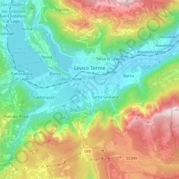
Name: Levico Terme topographic map, elevation, terrain.
Average elevation: 952 m
Minimum elevation: 423 m
Maximum elevation: 2,023 m
Other topographic maps
Click on a map to view its topography, its elevation and its terrain.
Mesiano
Italy > Trentino-Alto Adige/Südtirol > Provincia di Trento > Trento > Povo
Average elevation: 353 m
Cima Palon
Italy > Trentino-Alto Adige/Südtirol > Provincia di Trento
Cima Palon, also called Monte Pasubio, is the highest peak of the Pasubio group of Little Dolomites in Veneto, Italy. It has an elevation of 2,239 metres.
Average elevation: 1,896 m
Canazei
Italy > Trentino-Alto Adige/Südtirol > Provincia di Trento > Canazei > Canazei
Average elevation: 1,823 m
Rolle Pass
Italy > Trentino-Alto Adige/Südtirol > Provincia di Trento > San Martino di Castrozza
Average elevation: 1,996 m