
Paso Robles topographic map
Interactive map
Click on the map to display elevation.
Paso Robles
The topography of the area consists of gentle rolling hills on the eastern half of the city, and foothill peaks, which rise in elevation to the Santa Lucia Coastal Range on the west, which are all blanketed in the Californian chaparral environment, which is mainly dry grassland and oak woodland. Paso Robles sits on the eastern foothills of the Santa Lucia Coastal Mountain Range, which lies directly to the west of the city, and runs in a north–south direction, starting at Monterey, then runs south to its terminus in the San Luis Obispo area. The city is located at the southern end of the fertile Salinas River Valley, which is centered in between the Temblor Range (including the San Andreas Fault), which lie about 28 mi (45 km) to the east, and the Santa Lucia Coastal Range, which lies directly west, rising up from the city's western border. Paso Robles sits at the border where northern San Luis Obispo County and southern Monterey County meet, and is situated roughly 24 mi (39 km) inland from the Pacific Ocean.
About this map
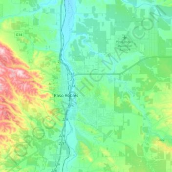
Name: Paso Robles topographic map, elevation, terrain.
Average elevation: 298 m
Minimum elevation: 193 m
Maximum elevation: 628 m
Other topographic maps
Click on a map to view its topography, its elevation and its terrain.