
Al Haouz Province topographic map
Interactive map
Click on the map to display elevation.
About this map
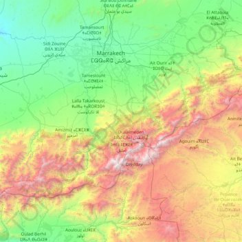
Name: Al Haouz Province topographic map, elevation, terrain.
Location: Al Haouz Province, Marrakech-Safi, Morocco (30.86304 -8.66143 31.69363 -7.13075)
Average elevation: 1,266 m
Minimum elevation: 214 m
Maximum elevation: 4,054 m
Other topographic maps
Click on a map to view its topography, its elevation and its terrain.
Small Forest Type Land
Morocco > Cercle de Chichaoua دائرة شيشاوة > Sidi Bouzid Arragragui
Average elevation: 469 m
Tangier
Tangier was formally known as Colonia Julia Tingi ("The Julian Colony of Tingis") following its elevation to colony status during the Roman Empire. It is also sometimes known as Boughaz (Arabic: بوغاز Meaning Inlet in English). The nicknames "Bride of the North" and "Door of Africa" reference its…
Average elevation: 52 m
Douar Lekbir Draa Ben Chekra
Morocco > cercle de Hrara > Ahrara > Douar Lekbir Draa Ben Chekra
Average elevation: 93 m