
Temuco topographic map
Interactive map
Click on the map to display elevation.
About this map
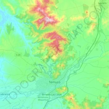
Name: Temuco topographic map, elevation, terrain.
Location: Temuco, Provincia de Cautín, Araucania Region, Chile (-38.78197 -72.82474 -38.54932 -72.46965)
Average elevation: 190 m
Minimum elevation: 32 m
Maximum elevation: 775 m
Other topographic maps
Click on a map to view its topography, its elevation and its terrain.
Volcán Llaima
Chile > Araucanía Region > Provincia de Cautín > Vilcún
The average elevation of the terrain around Llaima is about 740 m asl.
Average elevation: 2,519 m