
Ho Chi Minh City topographic map
Interactive map
Click on the map to display elevation.
Ho Chi Minh City
Ho Chi Minh City is located in the south-eastern region of Vietnam, 1,760 km (1,090 mi) south of Hanoi. The average elevation is 19 metres (62 ft) above sea level. It borders Tây Ninh Province and Bình Dương Province to the north, Đồng Nai Province and Bà Rịa–Vũng Tàu Province to the east, Long An Province to the west and the East Sea to the south with a coast 15 km (9 mi) long. The city covers an area of 2,095 km2 (809 sq mi or 0.63% of the surface of Vietnam), extending up to Củ Chi District (12 mi or 19 km from the Cambodian border) and down to Cần Giờ on the Eastern Sea. The distance from the northernmost point (Phú Mỹ Hưng Commune, Củ Chi District) to the southernmost one (Long Hòa Commune, Cần Giờ District) is 102 km (63 mi), and from the easternmost point (Long Bình ward, District Nine) to the westernmost one (Bình Chánh Commune, Bình Chánh District) is 47 km (29 mi).
About this map
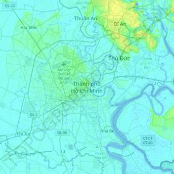
Name: Ho Chi Minh City topographic map, elevation, terrain.
Location: Ho Chi Minh City, 71006, Vietnam (10.61584 106.54176 10.93584 106.86176)
Average elevation: 6 m
Minimum elevation: -19 m
Maximum elevation: 75 m
Other topographic maps
Click on a map to view its topography, its elevation and its terrain.