Geolocate

Orange Beach topographic map

Interactive map

Click on the map to display elevation.

About this map

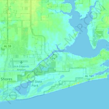
Name: Orange Beach topographic map, elevation, terrain.

Location: Orange Beach, Baldwin County, Alabama, United States (30.25450 -87.64991 30.34004 -87.51472)

Average elevation: 5 m

Minimum elevation: -4 m

Maximum elevation: 34 m

Other topographic maps

Click on a map to view its topography, its elevation and its terrain.

Daphne

United States > Alabama > Baldwin County

Daphne, Baldwin County, Alabama, 36526, United States

Average elevation: 25 m

Fairhope

United States > Alabama > Baldwin County

Fairhope, Baldwin County, Alabama, 36533, United States

Average elevation: 17 m

Bridgehead

United States > Alabama > Baldwin County > Spanish Fort

Bridgehead, Spanish Fort, Baldwin County, Alabama, 36527, United States

Average elevation: 22 m

Gulf Shores

United States > Alabama > Baldwin County

Gulf Shores, Baldwin County, Alabama, 36542, United States

Average elevation: 4 m

Foley

United States > Alabama > Baldwin County

Foley, Baldwin County, Alabama, 36535, United States

Average elevation: 20 m