
Boborás topographic map
Interactive map
Click on the map to display elevation.
About this map
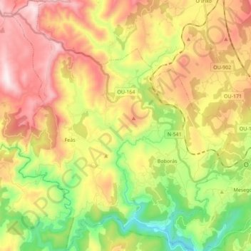
Name: Boborás topographic map, elevation, terrain.
Location: Boborás, O Carballiño, Orense, Galicia, 32514, España (42.38651 -8.24902 42.51250 -8.10014)
Average elevation: 492 m
Minimum elevation: 94 m
Maximum elevation: 934 m
Other topographic maps
Click on a map to view its topography, its elevation and its terrain.
Piñor
España > Galicia > O Carballiño
La orografía del término municipal aparece definida por dos unidades morfológicas. La primera está constituida por los conjuntos montañosas periféricos que bordean el término municipal por el norte y por el oeste, donde las altitudes son significativas, entre los 800-900 metros, especialmente en las…
Average elevation: 541 m