
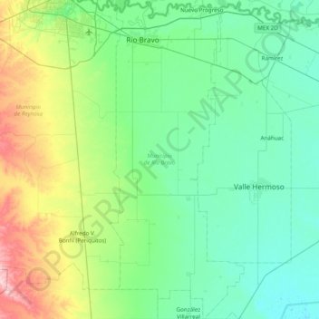
Río Bravo topographic map
Interactive map
Click on the map to display elevation.
About this map
Name: Río Bravo topographic map, elevation, terrain.
Location: Río Bravo, Tamaulipas, Mexico (25.38133 -98.17324 26.07443 -97.85004)
Average elevation: 42 m
Minimum elevation: 3 m
Maximum elevation: 196 m
Other topographic maps
Click on a map to view its topography, its elevation and its terrain.
Ciudad Victoria
Mexico > Tamaulipas > Victoria > Ciudad Victoria
Ciudad Victoria has short mild winters and long hot summers. Temperatures rarely drop below 0 °C (32 °F) — the lowest recorded temperature was −6 °C (21 °F) and the hottest was 48.5 °C (119.3 °F), one of the highest temperatures ever recorded in Mexico. The average annual precipitation is 700…
Average elevation: 518 m