
Helena topographic map
Interactive map
Click on the map to display elevation.
Helena
Helena is located at 46°35′45″N 112°1′37″W / 46.59583°N 112.02694°W / 46.59583; -112.02694 (46.595805, −112.027031), at an altitude of 4,058 feet (1,237 m).
About this map
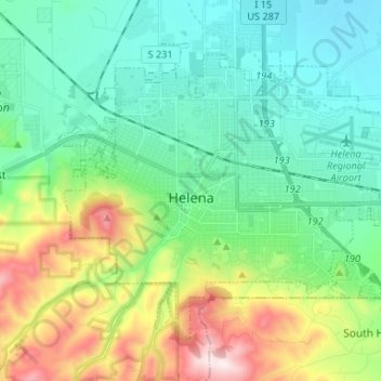
Name: Helena topographic map, elevation, terrain.
Location: Helena, Lewis and Clark County, Montana, United States (46.55922 -112.08328 46.62948 -111.95157)
Average elevation: 1,296 m
Minimum elevation: 1,128 m
Maximum elevation: 1,741 m