
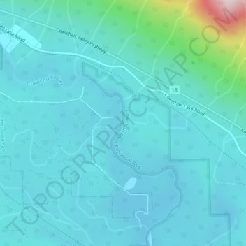
Josiah Creek topographic map
Interactive map
Click on the map to display elevation.
About this map
Name: Josiah Creek topographic map, elevation, terrain.
Average elevation: 220 m
Minimum elevation: 141 m
Maximum elevation: 800 m
Other topographic maps
Click on a map to view its topography, its elevation and its terrain.
Cowichan River
Canada > British Columbia > Area F (Cowichan Lake South / Skutz Falls)
Cowichan River, Area F (Cowichan Lake South / Skutz Falls), Cowichan Valley Regional District, British Columbia, Canada
Average elevation: 250 m
Carmanah Walbran Provincial Park
Canada > British Columbia > Area F (Cowichan Lake South / Skutz Falls)
Carmanah Walbran Provincial Park, Area F (Cowichan Lake South / Skutz Falls), Cowichan Valley Regional District, British Columbia, Canada
Average elevation: 365 m
Nitinat River Provincial Park
Canada > British Columbia > Area F (Cowichan Lake South / Skutz Falls)
Nitinat River Provincial Park, Cowichan Main, Upper Nitinat River Woodlands, Area F (Cowichan Lake South / Skutz Falls), Cowichan Valley Regional District, British Columbia, Canada
Average elevation: 361 m