Geolocate

Salvacion topographic map

Click on the map to display elevation.

About this map

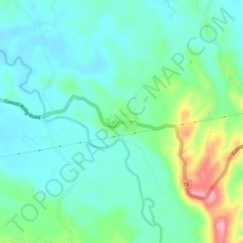
Name: Salvacion topographic map, elevation, terrain.

Location: Salvacion, Trento, Agusan del Sur, Caraga, 8505, Philippines (7.99041 126.10230 8.03041 126.14230)

Average elevation: 77 m

Minimum elevation: 46 m

Maximum elevation: 168 m

Gear up for your next adventure:

Backpacking Tent - Lightweight tent for long-distance hiking trips
🥽Outdoor Goggles - Protective eyewear for outdoor activities
🧤Insulated Winter Gloves - Heavy-duty protection for sub-zero Canadian adventures
🧭GPS Tracker - Track your location in remote areas safely
🥾Hiking Shoes - Durable and comfortable shoes for trail hiking

As an Amazon Associate, this site earns from qualifying purchases at no extra cost to you.