
Providence topographic map
Interactive map
Click on the map to display elevation.
About this map
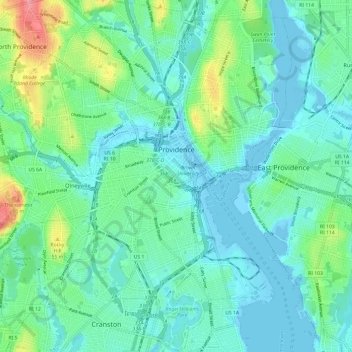
Name: Providence topographic map, elevation, terrain.
Location: Providence, Providence County, Rhode Island, United States (41.77243 -71.47267 41.86180 -71.37361)
Average elevation: 19 m
Minimum elevation: -8 m
Maximum elevation: 86 m
Other topographic maps
Click on a map to view its topography, its elevation and its terrain.
Greenville
United States > Rhode Island > Providence County > Greenville
Greenville, Providence County, Rhode Island, 02828, United States
Average elevation: 98 m
Foster
United States > Rhode Island > Providence County
Foster, Providence County, Rhode Island, 02825, United States
Average elevation: 171 m
Woonsocket
United States > Rhode Island > Providence County
Woonsocket, Providence County, Rhode Island, 02895, United States
Average elevation: 74 m
Cranston
United States > Rhode Island > Providence County
Cranston, Providence County, Rhode Island, United States
Average elevation: 27 m