
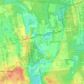
Middle Island topographic map
Interactive map
Click on the map to display elevation.
About this map
Name: Middle Island topographic map, elevation, terrain.
Average elevation: 31 m
Minimum elevation: 10 m
Maximum elevation: 63 m
Other topographic maps
Click on a map to view its topography, its elevation and its terrain.
Coram
United States > New York > Suffolk County > Town of Brookhaven
Coram, Town of Brookhaven, Suffolk County, New York, 11727, United States
Average elevation: 40 m
Ridge
United States > New York > Suffolk County > Town of Brookhaven
Ridge, Town of Brookhaven, Suffolk County, New York, 11961, United States
Average elevation: 28 m
East Patchogue
United States > New York > Suffolk County > Town of Brookhaven
East Patchogue, Town of Brookhaven, Suffolk County, New York, 11772, United States
Average elevation: 10 m
Centereach
United States > New York > Suffolk County > Town of Brookhaven
Centereach, Town of Brookhaven, Suffolk County, New York, 11720, United States
Average elevation: 39 m
Farmingville
United States > New York > Suffolk County > Town of Brookhaven
Farmingville, Town of Brookhaven, Suffolk County, New York, 11738, United States
Average elevation: 48 m
Water Island
United States > New York > Suffolk County > Town of Brookhaven
Water Island, Fire Island, Town of Brookhaven, Suffolk County, New York, United States
Average elevation: 0 m