
Make a donation
Gear up for your next adventure:
As an Amazon Associate, this site earns from qualifying purchases at no extra cost to you.
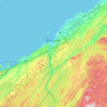
Rimouski topographic map
Click on the map to display elevation.
Make a donation
Gear up for your next adventure:
As an Amazon Associate, this site earns from qualifying purchases at no extra cost to you.
Rimouski
The tide station located at Pointe-au-Père serves as the reference point for measuring mean sea level for the North American Vertical Datum of 1988, which is the reference point for determining altitude in North America.
Make a donation
Gear up for your next adventure:
As an Amazon Associate, this site earns from qualifying purchases at no extra cost to you.
About this map
Name: Rimouski topographic map, elevation, terrain.
Average elevation: 126 m
Minimum elevation: -1 m
Maximum elevation: 540 m
Rimouski-Neigette trails, hiking, mountain biking, running and outdoor activities
Make a donation
Gear up for your next adventure:
As an Amazon Associate, this site earns from qualifying purchases at no extra cost to you.
Other topographic maps
Click on a map to view its topography, its elevation and its terrain.