Geolocate

Ingram topographic map

Click on the map to display elevation.

About this map

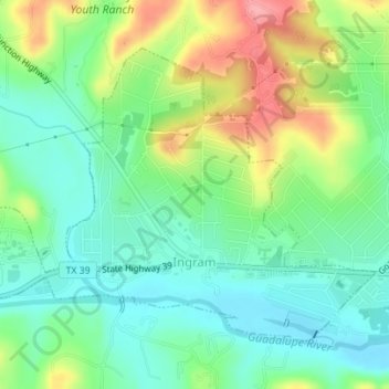
Name: Ingram topographic map, elevation, terrain.

Location: Ingram, Kerr County, Texas, United States (30.06775 -99.25512 30.09041 -99.22043)

Average elevation: 543 m

Minimum elevation: 506 m

Maximum elevation: 610 m

Other topographic maps

Click on a map to view its topography, its elevation and its terrain.

Kerrville

United States > Texas > Kerr County

Average elevation: 545 m

Gear up for your next adventure:

🪑Ultralight Camping Stool - Compact seating for rest stops during long hikes
🧢Outdoor Cap - Protective cap for sun and rain during hikes
🔋Lithium AA Batteries - Long-lasting power that performs in extreme cold
🕶️Polarized Sunglasses - Protect your eyes with durable polarized lenses
🧦Hiking Socks - Moisture-wicking and comfortable socks for long hikes

As an Amazon Associate, this site earns from qualifying purchases at no extra cost to you.