

Hermosillo topographic map
Click on the map to display elevation.
Hermosillo
The Cerro de la Campana mountain is one of the symbols of Hermosillo. Its summit is 350 metres (1,150 ft) above the valley floor and contains a lookout called El Caracol, which was inaugurated in 1909. There are two theories as to the origin of the mountain's name. One states that it is from a peculiar metallic sound that is made when the mountain's rocks fall against each other. The other is based on the bell-like shape of the elevation.
About this map
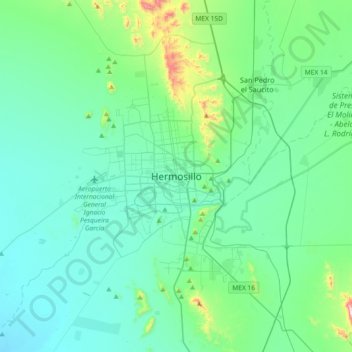
Name: Hermosillo topographic map, elevation, terrain.
Location: Hermosillo, Sonora, 83140, Mexico (28.93482 -111.12922 29.25482 -110.80922)
Average elevation: 248 m
Minimum elevation: 137 m
Maximum elevation: 875 m
Other topographic maps
Click on a map to view its topography, its elevation and its terrain.
