
Make a donation
Gear up for your next adventure:
As an Amazon Associate, this site earns from qualifying purchases at no extra cost to you.
Riccione topographic map
Click on the map to display elevation.
Make a donation
Gear up for your next adventure:
As an Amazon Associate, this site earns from qualifying purchases at no extra cost to you.
Riccione
Riccione's principal hill, to its south, is known as Cavrèt d'Arvura. Riccione's maximum elevation is 75 metres (246 feet) above sea level, with a mean elevation of 15.2 metres (50 feet).
Make a donation
Gear up for your next adventure:
As an Amazon Associate, this site earns from qualifying purchases at no extra cost to you.
About this map
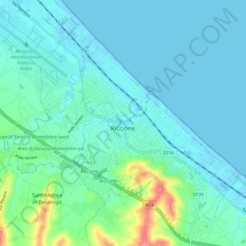
Name: Riccione topographic map, elevation, terrain.
Location: Riccione, Rimini, Emilia-Romagna, Italy (43.97382 12.60169 44.02534 12.68875)
Average elevation: 12 m
Minimum elevation: -6 m
Maximum elevation: 85 m
Make a donation
Gear up for your next adventure:
As an Amazon Associate, this site earns from qualifying purchases at no extra cost to you.