
Kensington Gardens topographic map
Interactive map
Click on the map to display elevation.
About this map
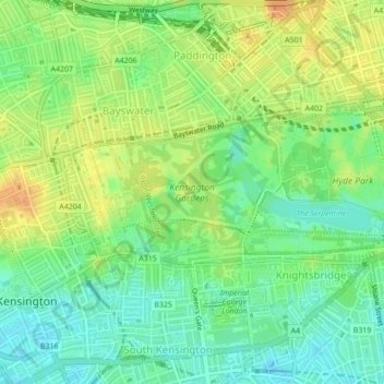
Name: Kensington Gardens topographic map, elevation, terrain.
Average elevation: 25 m
Minimum elevation: 8 m
Maximum elevation: 44 m
Other topographic maps
Click on a map to view its topography, its elevation and its terrain.
Hyde Park
United Kingdom > England > City of Westminster
Hyde Park, Knightsbridge, City of Westminster, Greater London, England, United Kingdom
Average elevation: 25 m