Geolocate

Malindi topographic map

Click on the map to display elevation.

About this map

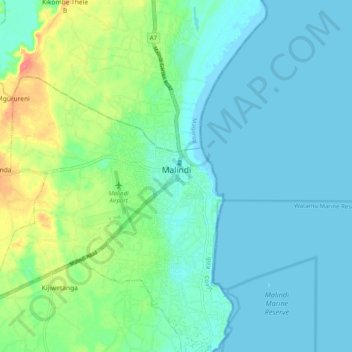
Name: Malindi topographic map, elevation, terrain.

Location: Malindi, Kilifi County, Coastal Kenya, 80200, Kenya (-3.26863 40.09009 -3.16837 40.13253)

Average elevation: 15 m

Minimum elevation: -1 m

Maximum elevation: 62 m

Gear up for your next adventure:

🎒Hiking Daypack - Lightweight and durable backpacks for day trips and excursions
🧊Portable Cooler - Keep food and drinks cold during outdoor adventures
👖Convertible Hiking Pants - Zip-off legs to adapt to changing weather conditions
🔨Vehicle Emergency Tool - Safety tool for remote road trips to trailheads
🧦Thermal Socks - Warm socks for winter hiking or camping

As an Amazon Associate, this site earns from qualifying purchases at no extra cost to you.