Geolocate

McGregor topographic map

Click on the map to display elevation.

About this map

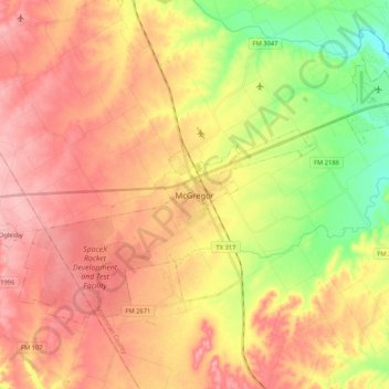
Name: McGregor topographic map, elevation, terrain.

Location: McGregor, McLennan County, Texas, 76657, United States (31.37749 -97.50334 31.49660 -97.29386)

Average elevation: 218 m

Minimum elevation: 151 m

Maximum elevation: 266 m

Other topographic maps

Click on a map to view its topography, its elevation and its terrain.

Elm Mott

United States > Texas > McLennan County

Average elevation: 156 m

Bruceville-Eddy

United States > Texas > McLennan County

Average elevation: 198 m

Hewitt

United States > Texas > McLennan County > Hewitt > Hewitt

Average elevation: 189 m

Waco

United States > Texas > McLennan County > Waco

Average elevation: 150 m

Gear up for your next adventure:

🥾Light Trekking Boots - Supportive boots for multi-day treks
🛁Quick-Dry Microfiber Towel - Space-saving towel that dries rapidly on the move
👖Convertible Hiking Pants - Zip-off legs to adapt to changing weather conditions
🦶Anti-Blister Balm - Prevents friction and hotspots during long ascents
🥾Waterproof Trail Shoes - Shoes designed to handle wet terrain

As an Amazon Associate, this site earns from qualifying purchases at no extra cost to you.