
Make a donation
Gear up for your next adventure:
As an Amazon Associate, this site earns from qualifying purchases at no extra cost to you.
Falcon State topographic map
Click on the map to display elevation.
Make a donation
Gear up for your next adventure:
As an Amazon Associate, this site earns from qualifying purchases at no extra cost to you.
Falcon State
Falcón State is located in the north of the Corian System. To the south, Falcón contains medium-altitude mountain ranges configured from east to west, which in the eastern part of the state reach the Caribbean Sea, forming maritime valleys.
Make a donation
Gear up for your next adventure:
As an Amazon Associate, this site earns from qualifying purchases at no extra cost to you.
About this map
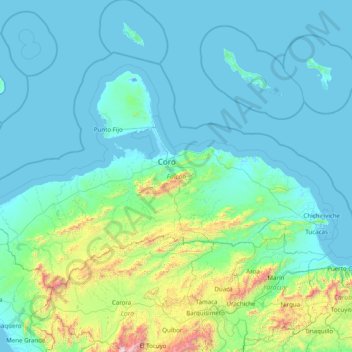
Name: Falcon State topographic map, elevation, terrain.
Location: Falcon State, Venezuela (10.29286 -71.28127 12.25552 -68.13742)
Average elevation: 221 m
Minimum elevation: -5 m
Maximum elevation: 2,875 m
Make a donation
Gear up for your next adventure:
As an Amazon Associate, this site earns from qualifying purchases at no extra cost to you.
Other topographic maps
Click on a map to view its topography, its elevation and its terrain.
Make a donation
Gear up for your next adventure:
As an Amazon Associate, this site earns from qualifying purchases at no extra cost to you.
Puerto La Cruz
Venezuela > Anzoategui State > Municipio Juan Antonio Sotillo > Puerto La Cruz
Average elevation: 97 m
Picacho del Diablo
Venezuela > Carabobo State > Municipio San Diego > Parroquia San Diego
Average elevation: 1,310 m
Make a donation
Gear up for your next adventure:
As an Amazon Associate, this site earns from qualifying purchases at no extra cost to you.