
Make a donation
Gear up for your next adventure:
As an Amazon Associate, this site earns from qualifying purchases at no extra cost to you.
Dharapuram topographic map
Click on the map to display elevation.
Make a donation
Gear up for your next adventure:
As an Amazon Associate, this site earns from qualifying purchases at no extra cost to you.
Dharapuram
Dharapuram is located at 10°44′N 77°31′E / 10.73°N 77.52°E / 10.73; 77.52. Dharapuram town is situated along of the bank of Amaravathi River which flows from the south to north. Uppar River and dam, Nallathankal River and dam, Palar join the river Amaravathi. It has an average elevation of 245 metres or 800 feet. It is strategically located in the line of Palakkad pass which provides the wind that activates the town's numerous windmills. The area has a significant water shortage. The town has a hot semi-arid climate (Köppen BSh).
Make a donation
Gear up for your next adventure:
As an Amazon Associate, this site earns from qualifying purchases at no extra cost to you.
About this map
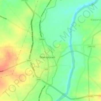
Name: Dharapuram topographic map, elevation, terrain.
Location: Dharapuram, Tiruppur District, Tamil Nadu, India (10.71908 77.48614 10.76112 77.53591)
Average elevation: 252 m
Minimum elevation: 229 m
Maximum elevation: 279 m
Make a donation
Gear up for your next adventure:
As an Amazon Associate, this site earns from qualifying purchases at no extra cost to you.