
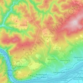
Rüdesheim am Rhein topographic map
Interactive map
Click on the map to display elevation.
Rüdesheim am Rhein topographic map, elevation, terrain
About this map
Name: Rüdesheim am Rhein topographic map, elevation, terrain.
Location: Rüdesheim am Rhein, Rheingau-Taunus-Kreis, Hesse, 65385, Germany (49.97184 7.83832 50.08597 7.94783)
Average elevation: 298 m
Minimum elevation: 74 m
Maximum elevation: 626 m