
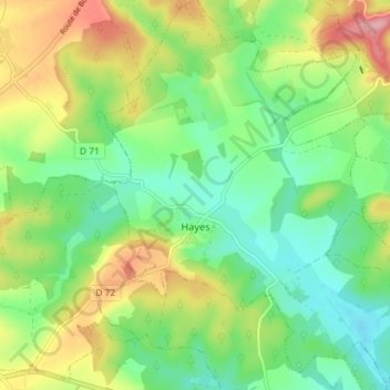
Hayes topographic map
Interactive map
Click on the map to display elevation.
About this map
Name: Hayes topographic map, elevation, terrain.
Average elevation: 259 m
Minimum elevation: 209 m
Maximum elevation: 341 m
Other topographic maps
Click on a map to view its topography, its elevation and its terrain.
Sentier du Moulin
France > Grand Est > Moselle > Château-Salins > Coutures
Sentier du Moulin, Coutures, Château-Salins, Sarrebourg-Château-Salins, Moselle, Grand Est, Metropolitan France, 57170, France
Average elevation: 243 m
Parson
France > Grand Est > Moselle > Lommerange
Parson, Lommerange, Thionville, Moselle, Grand Est, Metropolitan France, 57650, France
Average elevation: 286 m
Berg-sur-Moselle
France > Grand Est > Moselle > Berg-sur-Moselle
Berg-sur-Moselle, Thionville, Moselle, Grand Est, Metropolitan France, 57570, France
Average elevation: 168 m
Saint-Hubert
France > Grand Est > Moselle > Saint-Hubert
Saint-Hubert, Metz, Moselle, Grand Est, Metropolitan France, 57640, France
Average elevation: 261 m