
Redwood City topographic map
Click on the map to display elevation.
About this map
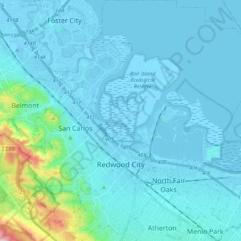
Name: Redwood City topographic map, elevation, terrain.
Location: Redwood City, San Mateo County, California, United States (37.44717 -122.29082 37.57038 -122.13750)
Average elevation: 32 m
Minimum elevation: -5 m
Maximum elevation: 355 m
Other topographic maps
Click on a map to view its topography, its elevation and its terrain.
Red Morton Community Park
United States > California > San Mateo County > Redwood City
Average elevation: 18 m
Bayshore Heights Park
United States > California > San Mateo County > Daly City
Average elevation: 84 m
Hillsborough Park
United States > California > San Mateo County > Hillsborough
Average elevation: 99 m
Highlands
United States > California > San Mateo County > San Mateo Highlands
Average elevation: 129 m
Princeton-by-the-Sea
United States > California > San Mateo County > El Granada
Average elevation: 33 m
Hillsborough Park
United States > California > San Mateo County > Hillsborough
Average elevation: 99 m
Daly City
United States > California > San Mateo County > Daly City
Several golf courses are located within or straddle the border with San Francisco. The Olympic Club has hosted the USGA U.S. Open five times, most recently in 2012, and will host both the 2028 PGA Championship and the 2032 Ryder Cup. The private San Francisco Golf Club and Lake Merced Golf Club have part or…
Average elevation: 32 m
Half Moon Bay
United States > California > San Mateo County > Half Moon Bay > Half Moon Bay
Average elevation: 73 m
Highlands
United States > California > San Mateo County > San Mateo Highlands
Average elevation: 129 m
San Carlos
United States > California > San Mateo County > San Carlos > San Carlos
Average elevation: 47 m