Geolocate

Campo topographic map

Click on the map to display elevation.

About this map
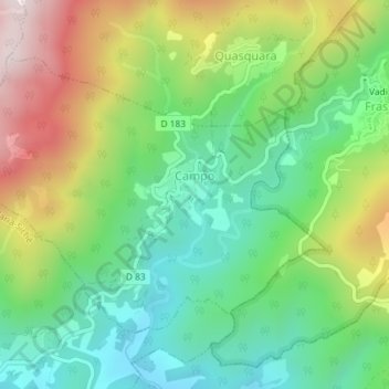
Name: Campo topographic map, elevation, terrain.

Location: Campo, Ajaccio, South Corsica, Corsica, Metropolitan France, 20142, France (41.88112 8.98452 41.90030 9.01791)

Average elevation: 708 m

Minimum elevation: 475 m

Maximum elevation: 1,100 m

Other topographic maps

Click on a map to view its topography, its elevation and its terrain.
Col de la Croix

France > Corsica > South Corsica > Osani

Average elevation: 182 m

Levie

France > Corsica > South Corsica > Levie > Levie

Average elevation: 630 m

Alzo Di Lano

France > Corsica > South Corsica > Zonza

Average elevation: 478 m

Vetriccia

France > Corsica > South Corsica > Partinello

Average elevation: 167 m

Gear up for your next adventure:

🧰Emergency Multi-Tool - Compact multi-tool for outdoor survival
🍽️Titanium Camping Spork - Ultralight and indestructible eating utensil
🧤Thermal Hiking Gloves - Grip-enhanced gloves for cold-weather altitude trekking
🧴Sunscreen SPF - Broad-spectrum sunscreen for outdoor activities
💧Reusable Water Bottle - Durable water bottles for hydration on trails

As an Amazon Associate, this site earns from qualifying purchases at no extra cost to you.