
Thank you for supporting this site ❤️
Make a donation
Make a donation
Gear up for your next adventure:
As an Amazon Associate, this site earns from qualifying purchases at no extra cost to you.
Albarracín topographic map
Click on the map to display elevation.
Thank you for supporting this site ❤️
Make a donation
Make a donation
Gear up for your next adventure:
As an Amazon Associate, this site earns from qualifying purchases at no extra cost to you.
About this map
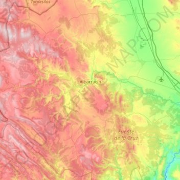
Name: Albarracín topographic map, elevation, terrain.
Location: Albarracín, Sierra de Albarracín, Teruel, Aragon, Spain (40.18504 -1.80644 40.58996 -1.25624)
Average elevation: 1,330 m
Minimum elevation: 790 m
Maximum elevation: 1,924 m
Thank you for supporting this site ❤️
Make a donation
Make a donation
Gear up for your next adventure:
As an Amazon Associate, this site earns from qualifying purchases at no extra cost to you.