Geolocate

Rawdon topographic map

Click on the map to display elevation.

About this map

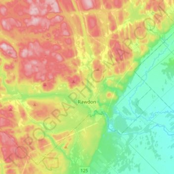
Name: Rawdon topographic map, elevation, terrain.

Location: Rawdon, Matawinie, Lanaudière, Quebec, J0K 1S0, Canada (45.97702 -73.88191 46.14501 -73.61023)

Average elevation: 197 m

Minimum elevation: 54 m

Maximum elevation: 403 m

Matawinie trails, hiking, mountain biking, running and outdoor activities

Other topographic maps

Click on a map to view its topography, its elevation and its terrain.

Lac Sokol

Canada > Quebec > Matawinie > Chertsey

Average elevation: 282 m

Notre-Dame-de-Beaulac

Canada > Quebec > Matawinie > Chertsey

Average elevation: 344 m

Baie Pinata

Canada > Quebec > Matawinie > Baie-Obaoca

Average elevation: 436 m

Lac d'Argent

Canada > Quebec > Matawinie > Chertsey

Average elevation: 281 m

Baie Ignace

Canada > Quebec > Matawinie > Saint-Michel-des-Saints

Average elevation: 398 m

Lac Mooney

Canada > Quebec > Matawinie > Chertsey

Average elevation: 365 m

Lac Désert

Canada > Quebec > Matawinie > Chertsey

Average elevation: 343 m

Mont Garceau

Canada > Quebec > Matawinie > Saint-Donat

Average elevation: 534 m

Gear up for your next adventure:

🛏️Camping Sleeping Mat - Comfortable mats for sleeping outdoors
❄️Traction Ice Cleats - Slip-on spikes for icy trails and winter hiking
🥾Waterproof Trail Shoes - Shoes designed to handle wet terrain
🧢Sun Protection Cap - Breathable cap to protect from sun exposure
🎒Hiking Daypack - Lightweight and durable backpacks for day trips and excursions

As an Amazon Associate, this site earns from qualifying purchases at no extra cost to you.