Geolocate

Bacoor topographic map

Click on the map to display elevation.

About this map

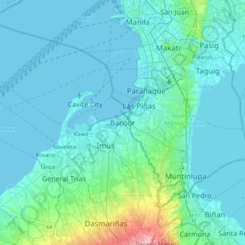
Name: Bacoor topographic map, elevation, terrain.

Location: Bacoor, Cavite, Calabarzon, 4102, Philippines (14.27144 120.80636 14.59144 121.12636)

Average elevation: 26 m

Minimum elevation: -3 m

Maximum elevation: 219 m

Other topographic maps

Click on a map to view its topography, its elevation and its terrain.

Molino Dam

Philippines > Cavite > Bacoor

Average elevation: 37 m

Bacoor River

Philippines > Cavite > Bacoor

Average elevation: 8 m

Gear up for your next adventure:

🧳Compression Sacks - Maximize space in your backpack by shrinking gear
🥾Durable Hiking Shoes - Long-lasting shoes for frequent hiking
🔦UV Flashlight - Detect minerals or specific insects in the dark
🧥Ultralight Puffy Jacket - Maximum warmth that packs down to the size of an orange
🧼Biodegradable Camp Soap - Environmentally friendly cleaning for gear and body

As an Amazon Associate, this site earns from qualifying purchases at no extra cost to you.