Geolocate

Congleton topographic map

Click on the map to display elevation.

About this map

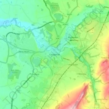
Name: Congleton topographic map, elevation, terrain.

Location: Congleton, Cheshire East, England, United Kingdom (53.13596 -2.25081 53.19023 -2.14072)

Average elevation: 119 m

Minimum elevation: 59 m

Maximum elevation: 244 m

Other topographic maps

Click on a map to view its topography, its elevation and its terrain.

Collins Wood

United Kingdom > England > Cheshire East

Average elevation: 91 m

Gear up for your next adventure:

🚲Heavy Duty Bike Lock - Secure your bike at the trailhead or during stops
🥾Durable Hiking Shoes - Long-lasting shoes for frequent hiking
💧Collapsible Water Bottle - Space-saving water bottle for outdoor activities
💧Hydration Pack - Hands-free hydration system for long hikes
🛌Insulated Sleeping Pad - Critical thermal barrier between you and the cold ground

As an Amazon Associate, this site earns from qualifying purchases at no extra cost to you.