Geolocate

Vannes topographic map

Click on the map to display elevation.

About this map

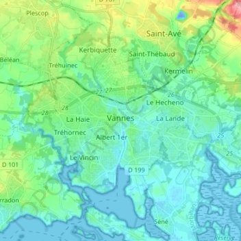
Name: Vannes topographic map, elevation, terrain.

Location: Vannes, Morbihan, Brittany, Metropolitan France, 56000, France (47.62085 -2.81555 47.69456 -2.68166)

Average elevation: 24 m

Minimum elevation: -23 m

Maximum elevation: 117 m

Gear up for your next adventure:

🥾Light Hiking Boots - Lightweight and comfortable boots for day hikes
💧Hydration Bladder - Hands-free hydration solution for long treks
🧴First Aid Kit - Essential first aid supplies for outdoor emergencies
🔭Outdoor Binoculars - Lightweight binoculars for birdwatching and hiking
🥾Waterproof Hiking Shoes - Durable shoes for wet and rugged trails

As an Amazon Associate, this site earns from qualifying purchases at no extra cost to you.